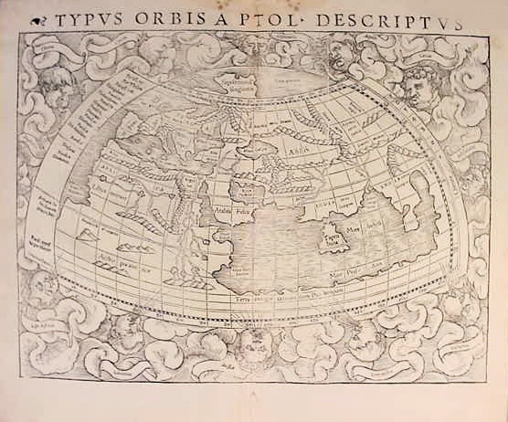
The Power of Maps -- Art and Destiny
The Academy for Lifelong Learning -- Autumn 2013
Introducing Your Course Leader:
Lorraine Sherry [biography]
Lorraine's Cell phone: 303-807-0609
E-mail:
lorraine.sherry@comcast.net
Home phone: 303-465-4361
Course Description:
Antique maps represent a combination of art, history, and beliefs. (There be dragons here!) Maps made us who we are. Columbus would not have sailed west without the influence of a map. Lewis and Clark would never have started their explorations without maps. But where did these maps come from? Many are extremely rare and valuable. Learn from our experts in antiquarian maps about the history of cartography from Homer in the 8th century B.C., to Ptolemy of Alexandria, to Biblical world views, to the great atlases following Gutenburg, and finally to Google Earth; the art of discovery; the development and continuous shifting of political boundaries; how American territories and states got their shapes; and finally, discover some interesting cartographic myths and mistakes.
Course Format:
Enjoy lecture/PowerPoint presentations by members of the Rocky Mountain Map Society with lots of Q/A. This is course is NOT focused on being a discussion group. We're here to hear scholarly presentations by real experts and to see some extremely rare original maps.
Logistics:
The class will meet on six Thursday afternoons (October 17 through November 21) from 1:30 to 3:30 PM. The classroom will be assigned after Academy registration has begun.
Learning Objectives: Gain an appreciation of antiquarian maps; learn how maps have influenced history and politics; and understand the fascination of collecting antique maps and other items of cartographic interest.
Class Website: You should have access to a computer to view the Class Schedule and Guest Presenter Information on the class website. The link (below) will take you to the class website.
http://home.comcast.net/~lorraine.sherry/cartography/index.html
Class Schedule: 1:30 - 3:30 PM Thursdays
|
Week 1 -- Oct. 17
David Cole
Meandering Maps, Memories, and Myths
|
Week 2 -- Oct. 24
Wesley A. Brown
The Discovery of the New World through Old Maps
|
Week 3 -- Oct. 31
Angel Abbud-Madrid
Where to Draw the Line? Mapping the US-Mexican Border
|
Week 4 -- Nov. 7
Christopher Lane
The Political Development of the Trans-Mississippi US in Period Maps
|
Week 5 -- Nov. 14
Thomas Overton
The Changing Face of Colorado - County Boundaries 1861-1913
- and -
Ronald Gibbs
Captain James Cook and the Art of Discovery
|
Week 6 -- Nov. 21
Don McGuirk
Cartographic Myths of North America
|
|
|
Guest Presenter Information
|
|
Our Guest Presenters
Photos and
Biographical Sketches
|
Presenter Affiliations,
Map-Related Events,
and Synopsis of Presentation
|
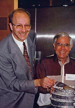
David Cole [right]
Past President, Rocky Mountain Map Society
Retired [HP - Europe]
Biography
|
Meandering Maps, Memories, and Myths
Dave Cole's presentations fall into two parts, using antique maps to "meander" the world through 400 years of history. The maps and their stories allow you to participate in learning about history, art, and cartography, He makes extensive use of antique maps, art, currency, and historical quotations to enrich your experience.
Part I is a 45-minute introduction to antique maps covering the Prime Meridian, types of printing methods employed, primary languages (Old English, Latin, Italian, French, Dutch, and German), and artistic embellishments (sea monsters, compass roses, cartouches, vignettes, ornate scripts, etc).
Part II is a 60-minute "meandering" of the world permitting the antique maps, by their content, to trigger historical stories. Some of the topics that Dave will cover include celebrated myths (California as an Island, Sea Monsters), historical footprints of man (Pyramids, Canals, Mines, the Tower of Babel, Great Wall of China), historical footprints of God (Biblical references), and maps of the Period of Discovery.
|

Wesley A. Brown
Founder, Rocky Mountain Map Society
Co-Founder, St. Charles Capital
Biography
|
The Discovery of the New World through Old Maps
Through the study of maps, Wesley Brown will investigate man's conception of the shape of the Earth through history and will give particular focus to the discovery of the New World. This general survey will begin with Homer in the 8th century B.C. and will end with Sebastian Munster in the middle of the 16th century. The talk will be illustrated with slides of original antique maps from his own collection, printed between 1472 and 1540.
|

Dr. Angel Abbud-Madrid
President, Rocky Mountain Map Society
Director, Center for Space Resources
Colorado School of Mines
Biography
|
Where to Draw the Line? Mapping the US-Mexican Border
At the end of 1847, representatives from the governments of the United States and Mexico gathered on a small town near Mexico City to negotiate the terms of a peace treaty to end the war between the two countries. At stake was an enormous land cession from Mexico of more than half of the US pre-war territory corresponding to the modern-day states of Arizona, New Mexico, California, Nevada, and Utah, and parts of Wyoming and Colorado.
Used as an integral part of the hard-fought negotiations was a commercially successful, but seriously flawed map on which the new borderline was drawn. Using maps, government reports, diaries, and other relevant material from American and Mexican sources, this presentation will explore the long-lasting impact of the various interpretations of this most unique map on subsequent borderline mapping efforts and on the convoluted political, social, and economic relations between the US and Mexico for the last 160 years.
|
Christopher Lane
Director, Rocky Mountain Map Society
Co-Owner, Philadelphia Print Shop West, Antiques Road Show Appraiser
Biography
|
The Political Development of the Trans-Mississippi United States in Period Maps
How did the states REALLY get their shapes? Learn about the transformation of the American West from three foreign territories to nineteen states and four U.S. territories as meticulously documented by nineteenth century mapmakers.
Chris has appeared, along with his business partner, Donald H. Cresswell, as the regular print and map appraisers for public television's "Antiques Roadshow."
|

Thomas Overton
Past President, Rocky Mountain Map Society
Founder, The Overton Law Firm
Biography
|
The Changing Face of Colorado - County Boundaries 1861-1913
Did you know that back in 1861, the state that we now know as Colorado existed solely of 17 counties plus an Indian reservation? The City and County of Denver was only created 40 years later in 1901; and the most recent addition - Broomfield County - the 64th county - was just added in 2001, 100 years after Denver. Over these fourteen decades, mountain ranges have had their names changed, and there have been major shifts in county boundaries. In his presentation, Tom hopes to cover the changes, the reasons behind those changes, and a little about some of the people for whom the counties were named.
Authored by current RMMS President Tom Overton, Mark Greaves, and RMMS Founder Wes Brown, the first official publication of the Rocky Mountain Map Society, Occasional Paper Series, No. 1, is the "Atlas of Colorado Counties 1861-2001." The Atlas shows how the counties of Colorado were legally defined over the years, providing a quick reference for identifying undated maps of Colorado.
|

Ronald Gibbs, MD
Director, Rocky Mountain Map Society
Professor of Obstetrics and Gynecology
and Associate Dean for
Continuing Medical Education,
University of Colorado
School of Medicine
Biography
|
Captain James Cook and the Art of Discovery
Captain James Cook, one of the world's great sea captains, rose from a simple farm boy to Captain of the British Royal Navy, commanding two Royal Navy vessels on three historic journeys that would forever link his name with fearless exploration. The Endeavor's voyage (1768-1771) changed the face of modern exploration. Captain Cook is recognized for charting the Pacific Ocean, the eastern coasts of New Zealand and Australia, and exploring Tahiti, Tierra del Fuego, and Rio de Janeiro.
During the voyages of the Resolution (1772-1775 and 1776-1780), Cook returned to the southern oceans to search for Terra Australis, but he never found it. By carrying Harrison's H4 clock on the Resolution, Cook proved that a chronometer could give seamen the means to accurately determine longitude. Ron Gibbs will illustrate the thrilling story of this 18th century "super star" explorer with some of his own maps.
|

Donald McGuirk, MD
Past President, Rocky Mountain Map Society
Retired Physician
Biography
|
Cartographic Myths of North America
"The Last Great Cartographic Myth: Mer de l'Ouest" is a cartobibliography by RMMS Past President Don McGuirk. This is a groundbreaking work, not just in terms of being the first published cartobibliography covering the Mer de l'Ouest, but also in terms of being the first cartobibliography published in electronic format. The "Mer de l'Ouest" (Sea of the West) was a Mediterranean size sea first placed on maps of North America in 1700. How this sea was conceived and its subsequent 100-year history will be discussed in detail using frequent map examples from Don's recent book, published by Map Record Publications.
Besides the Sea of the West, other topics will include unusual early depictions of North America on maps, California as an island, and the history of several unusual maps that show North America double its correct size. Don will also elaborate on various other myths and mistakes that are found in antique maps dating from the 18th century until scientific surveys provided accurate information to mapmakers and explorers during America's westward expansion.
|
Recommended Readings
These are just a few of my favorite map-related books.
- Potter, J. (1988). Collecting Antique Maps. London: Jonathan Potter LTD
- Manasek, F.J. (2000). Collecting Old Maps. Norwich VT: Terra Nova Press.
- Wilford, J.N. (2000). The Mapmakers [Revised Edition]. NY: Alfred A. Knopf.
- Schwartz & Ehrenberg. (2001). The Mapping of America. Edison NJ: Wellfleet Press.
- Greaves, Overton, & Brown. (2007). Atlas of Colorado Counties. Denver: Rocky Mountain Map Society. (out of print)
About the Rocky Mountain Map Society (RMMS)
The Rocky Mountain Map Society
is a non-profit organization dedicated to the study and appreciation of maps, cartographic history, the history of exploration and discovery, maps as art, collecting antique maps, and other areas of cartographic interest. Public outreach by the Society to provide education in maps and history is performed by providing speakers, exhibits, and instruction to its members as well as to public schools, adult education programs, museums, and other outside forums. It has also co-sponsored with the Denver Public Library several Antique Map Fairs with lectures and dealer displays from around the world. The Society is a founding member of the Council of North American Map Societies and works closely with the Geography and Map Division of the Library of Congress. Recognized internationally, the Society hosted the 2001 Annual Meeting of the Society for the History of Discoveries, the 2005 Conference of the International Map Collectors Society, and in 2012, an international conference titled "The Mapping of North America: The Westward Expansion" with the Texas Map Society and the University of Denver. The Society was formed in 1991 and is headquartered in Denver, Colorado. More information can be found on the Society's website,
www.RMmaps.org
Dr. Lorraine Sherry
Course Leader: The Academy for Lifelong Learning
The Power of Maps: Fall Term, 2013
Website updated July 21, 2013
E-mail Lorraine Sherry
|